Torre Panorâmica
Visão geral


Suporte da telefonia celular está no ponto mais alto de Curitiba, permitindo uma visão da cidade em 360 graus. Sua altura é de 109,5 metros ficando numa altitude 1.050 metros do nível do mar. Inaugurada em 17 de dezembro de 1991 e é administrada em conjunto pela Brasil Telecom e o Instituto Municipal de Turismo que ali promove sessões de vídeo e fornece orientações turísticas, abrigando também o Museu do Telefone.

Location:
Javascript is required to view this map.
Comments (1)
Connections
Compare related sites, explore the related maps, find out about volunteering, how to get here and more. Soon, you will find ways to share this map here, too.
Every site using the same primary Icon on Open Green Map is automatically linked here. You can compare different approaches and solutions on this map and others around the world.
Choose a connections category from the list on the left.
Other Sites on Map
- Curitiba
Related Sites Worldwide
- Cesky KrumlovCzech Republic
- FlorianópolisBrazil
- IthacaUnited States
-
- Staten IslandUnited States
- Italy
-
- Brazil
- Mountainville, NY
- New YorkUnited States
- taoyuan countyTaiwan
- Copper Harbor
- Baltimore, MDUnited States
- United Kingdom
-
- EspooFinland
-
-
- United Kingdom
- Cape TownSouth Africa
-
- BaltimoreUnited States
- GranvilleUnited States
- SarasotaUnited States
- Staatsburg, NY
Multimedia
 added by
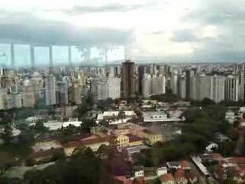

Impacts
No impacts have been left for this site yet - be the first!


