La bisse du Trient
Vue d'ensemble


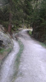
Jusqu'à la fin du 19ème siècle, les habitants de la vallée du Trient exploitaient la glace du glacier de Trient pour la vendre aux grands hôtels genevois, lyonnais et même parisiens. Ils cassaient la glace jusqu'à 10 m de profondeur par jour et la récupérait dans le torrent en aval, au niveau de la buvette. A cet endroit, une dérivation du torrent a été créée pour alimenter les cultures de Martigny. Cette dérivation s'appelle une bisse et nous pouvons la suivre jusqu'au col de la Forclaz. Un chemin pédagogique a été mis en place il y a quelques années le long de cette bisse.

Location:
Javascript is required to view this map.
Commentaires
Connections
Compare related sites, explore the related maps, find out about volunteering, how to get here and more. Soon, you will find ways to share this map here, too.
Every site using the same primary Icon on Open Green Map is automatically linked here. You can compare different approaches and solutions on this map and others around the world.
Choose a connections category from the list on the left.
Other Sites on Map
nd
Related Sites Worldwide
- Estados Unidos
- SarasotaEstados Unidos
- SarasotaEstados Unidos
- EnglewoodEstados Unidos
- SarasotaEstados Unidos
- VeniceEstados Unidos
- SarasotaEstados Unidos
- North PortEstados Unidos
- Longboat KeyEstados Unidos
- NokomisEstados Unidos
- SarasotaEstados Unidos
- SarasotaEstados Unidos
- Estados Unidos
- SarasotaEstados Unidos
- Estados Unidos
- NokomisEstados Unidos
- Taiwan
- SarasotaEstados Unidos
- CranfordEstados Unidos
- SarasotaEstados Unidos
- SarasotaEstados Unidos
- Reino Unido
- SarasotaEstados Unidos
- ClevelandEstados Unidos
- WenonahEstados Unidos
Multimedia

La bisse du Trient

Impacts
No impacts have been left for this site yet - be the first!


