員鹿路2段30巷136號 (鄉長宅邸旁)
彰化縣埔心鄉義民村
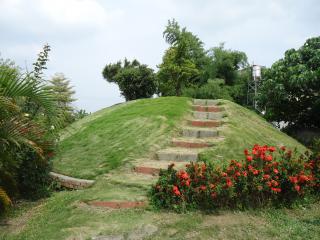
望高寮測量點
概览


早年是個寬闊的高聳土墩,上面有個平台,提供政府單位測量土地的據點。耆老說,日治時期曾經有測量的直昇機做著高空測量工作,當時在望高寮的地面擺放著一個大正方形的帆布,中間畫著很大的同心圓。站在望高寮,可以向東邊看到東山與草屯的另外據點。目前的望高寮上,安放著三角點石碑,也栽種著一些綠樹植栽,成為單車道的景點之一。

Location:
Javascript is required to view this map.
评论
Connections
Compare related sites, explore the related maps, find out about volunteering, how to get here and more. Soon, you will find ways to share this map here, too.
Every site using the same primary Icon on Open Green Map is automatically linked here. You can compare different approaches and solutions on this map and others around the world.
Choose a connections category from the list on the left.
Other Sites on Map
- 彰化縣埔心鄉
- 彰化縣埔心鄉埤腳村
- 彰化縣埔心鄉埤腳村
- 彰化縣埔心鄉
- 彰化縣埔心鄉二重村
- 彰化縣埔心鄉義民村
- 彰化縣埔心鄉
- 彰化縣埔心鄉
- 彰化縣埔心鄉大華村
- 彰化縣埔心鄉埤霞村
Related Sites Worldwide
- Jersey City美国
- Midland加拿大
- Cluj Napoca罗马尼亚
- New York美国
- 美国
- 英国
- Yogyakarta印度尼西亚
-
- 英国
-
- New York美国
- Baltimore美国
- decatur美国
- Florianópolis巴西
- Charleston美国
- Blawenburg美国
- Yarmouth加拿大
- Baltimore美国
- 美国
- 巴西
- Atlantic美国
- Sealevel美国
- Montclair美国
- Yarmouth加拿大
- 英国
Multimedia
望高寮測量點


Impacts
No impacts have been left for this site yet - be the first!


