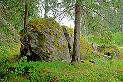
Akmeņkalnu Velna pēdas akmens (Vanagu akmens) / Akmenkalni Devil's Footprint boulder (Vanagi boulder)
概览
Liels, ainavisks akmens, aptuvenais akmens tilpums - 40 kubikmetri. Gaišpelēks ortogneiss, 5,6 metrus garš un 3,3 metrus augsts.
Dundagas, Puzes un Ances pagastu sadures vietā, līdzās jaunizbūvētam meža ceļam.
Large, picturesque boulder, approximate volume of boulder - 40 cubic metres. Grey orthogneiss, 5,6 metres long and 3,3 metres high.
Borderpoint of Dundaga, Puze and Ance municipalities, at the side of newly built forest road.
Location:
Javascript is required to view this map.
评论
Connections
Compare related sites, explore the related maps, find out about volunteering, how to get here and more. Soon, you will find ways to share this map here, too.
Every site using the same primary Icon on Open Green Map is automatically linked here. You can compare different approaches and solutions on this map and others around the world.
Choose a connections category from the list on the left.
Other Sites on Map
Related Sites Worldwide
-
- Gainesville美国
- 葡萄牙
- Hong Kong中国香港特别行政区
-
-
-
-
- 阿鲁巴
- 意大利
- Gainesville美国
- 美国
- Boiling Springs美国
- 葡萄牙
- 葡萄牙
-
- 瑞士
-
- Lincoln美国
-
-
-
-
-
- 瑞士
Impacts
No impacts have been left for this site yet - be the first!


 added by


