公車與停靠站
Übersicht


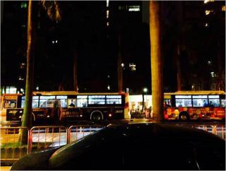
在這張圖看到的是交通工具,人家都說在台北市很方便,原因就在於台北市的大眾運輸設施很多,即使沒有自己的汽機車,也能透過捷運公車甚至計程車來來解決外出的問題,不但減少碳排放量,也降低能源耗損。台北的公車路線圖五花八門,轉乘的方法有千百種,因此,政府也都幫民眾想好了如何轉車搭車,隨著科技的發達,在google的地圖裡更能得到路線跟轉乘資訊,能選擇自己喜愛的方法到達目的地。現在台北的公車大多有安裝gps的裝置,透過衛星的定位,公車的資訊欄就會顯示還有幾站到站,也有越來越多公車採用低底盤車種,並設有殘障區域,讓行動不便的人也能外出搭車,考慮相當周到。(文化機械林胤、裘子慶、李孟學、吳至璿、文化土資 方大城、許順銘)

Location:
Javascript is required to view this map.
Kommentare
Verbindungen
Compare related sites, explore the related maps, find out about volunteering, how to get here and more. Soon, you will find ways to share this map here, too.
Every site using the same primary Icon on Open Green Map is automatically linked here. You can compare different approaches and solutions on this map and others around the world.
Choose a connections category from the list on the left.
Ähnliche Orte weltweit
- SandtonSouth Africa
- AkronUnited States
- United States
- New YorkUnited States
- BrooklynUnited States
- Germany
- United States
- MalmöSweden
- United States
- United States
- United Kingdom
- BrooklynUnited States
- Brazil
- YogyakartaIndia
- United States
- GenèveSwitzerland
- United States
- FlorianópolisBrazil
- FlorianópolisBrazil
- QuincyUnited States
- NY
- Atlanta, GA
- Santana de ParnaíbaBrazil
- GenèveSwitzerland
- New YorkUnited States
Multimedia
公車與停靠站


Auswirkungen
No impacts have been left for this site yet - be the first!


