Myrna Peters Rd
Kinnakeet
NC 27968
Rodanthe Harbor
Overview

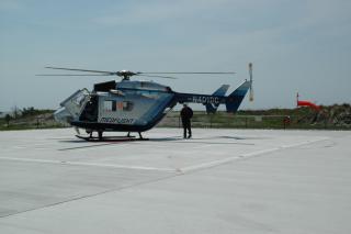
The Rodanthe Harbor, sometimes called “The Creek,” was dug in 1936-37 by the U.S. Coast Guard to supply the Chicamacomico Station. The Harbor remains a working waterfront. On the harbor is one of the last-remaining small commercial fish houses on North Carolina’s coast. Additionally, on Dare County-owned land, is (1) a volunteer- maintained recycling center serving residents and visitors year round, seven days a week; (2) emergency helicopter landing pad; (3) a dredge spoil area; and (4) an emergency ferry dock.
The Harbor served as a site for a WPA camp.
252-987-1303

Location:
Javascript is required to view this map.
Comments
Connections
Compare related sites, explore the related maps, find out about volunteering, how to get here and more. Soon, you will find ways to share this map here, too.
Every site using the same primary Icon on Open Green Map is automatically linked here. You can compare different approaches and solutions on this map and others around the world.
Choose a connections category from the list on the left.
Other Sites on Map
- Salvo
- Buxton
Related Sites Worldwide
- BaltimoreUnited States
-
- Portugal
-
- United States
- Longboat KeyUnited States
- CaliColombia
- CuritibaBrasilien
- SarasotaUnited States
- DurbanSouth Africa
- VeniceUnited States
- CaliColombia
- HelsinkiFinland
- KyotoJapan
- Lido KeyUnited States
- Kanada
- VeniceUnited States
- Hong Kong S.A.R., China
- Flagstaff
- South Africa
- Belgien
- United States
- CaliColombia
- KarlskronaSverige
- RichmondUnited States
Multimedia
Rodanthe Harbor


Impacts
No impacts have been left for this site yet - be the first!


