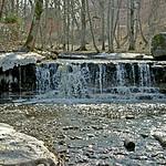
Īvandes apakšējā rumba (Rendas Lielā rumba) / Ivande lower waterfall (Renda Big Waterfall)
Visão geral
Skaists ūdenskritums ar acij tīkamu augstuma un platuma attiecību - pilnīgi vertikālais ūdenskritums ir ap 2 metrus augsts un ap 9 metrus plats.
Rendas centrā, pie autobusa pieturas.
Beautiful waterfall with great proportion of width and height - waterfall is vertical, some 2 metres high and some 9 metres wide.
Centre of Renda, near the bus stop.
Location:
Javascript is required to view this map.
Comentários
Connections
Compare related sites, explore the related maps, find out about volunteering, how to get here and more. Soon, you will find ways to share this map here, too.
Every site using the same primary Icon on Open Green Map is automatically linked here. You can compare different approaches and solutions on this map and others around the world.
Choose a connections category from the list on the left.
Other Sites on Map
Related Sites Worldwide
- United States
- United States
-
- WenonahUnited States
- MoorestownUnited States
- United States
- MontclairUnited States
- FergusonUnited States
- Japan
- United States
-
- United States
- MontclairUnited States
- FanwoodUnited States
- Italy
- DavosSwitzerland
- KitchenerCanada
- SummitUnited States
- ConstantaRomania
- San AntonioUnited States
- RochesterUnited States
- North VeniceUnited States
- CamdenUnited States
- Romania
- CamdenUnited States
Impacts
No impacts have been left for this site yet - be the first!


 added by


