Envigado
ANT
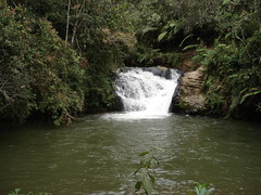
Charco Azúl
Rezumat
Las aguas que atraviesan a Pantanillo, confluyen todas en la quebrada el Espíritu Santo y esta a su vez, desemboca en la Represa La Fe. Charco Azul, lugar muy frecuentado por bañistas. Es la zona predilecta por quienes prefieren acampar.
Location:
Javascript este necesar pentru a vizualiza harta.
Comentarii
Conexiuni
Compare related sites, explore the related maps, find out about volunteering, how to get here and more. Soon, you will find ways to share this map here, too.
Every site using the same primary Icon on Open Green Map is automatically linked here. You can compare different approaches and solutions on this map and others around the world.
Choose a connections category from the list on the left.
Other Sites on Map
- Envigado
- Envigado
- Envigado
- Envigado
Related Sites Worldwide
- South Africa
- EhingenGermany
- Hong Kong S.A.R., China
- United States
- Hong Kong S.A.R., China
- FifeUnited Kingdom
- Canada
- United States
-
- RonnebySweden
- South Africa
- Cluj-NapocaRomania
- United States
- United States
- KirtlandUnited States
- Utica
- SarasotaUnited States
- Canada
- PereiraColombia
- IthacaUnited States
- United States
- Baltimore, MDUnited States
- LincolnUnited States
-
- GlenfordUnited States
Impact
gsc Ian 2009 "les presentamos la manera para construir los tanques para cultivo de truchas vía botellitas ... http://ereciclaje.wordpress.com/el-punto-com/"


 adăugat de Anonymous


