Bluff
Rezumat


BLUFF
A bluff is a type of broad, "steep cliff which borders a river or other coastal area" (2010). They can also be known as a hill slope and typically form where a river meanders, or curves. When the dip in a river bank breaks or is no longer supported, "the upper part of the bank breaks off, leaving the high wall of a bluff" (2016). Bluffs widen due to erosion along the flood plain of a river as meandering gradually shifts it from side to side. Bluffs can be compared to cliffs, as they are due to a body of water pushing against the land. The biggest difference between the two is that bluffs slope downwards into a body of water, whereas cliffs typically stay more leveled or up high.
SOURCES:
Evers, J. (2016, February 09). Bluff. Retrieved July 07, 2019, from https://www.nationalgeographic.org/encyclopedia/bluff/
StLouisCountyMN. (2010, May 03). How to Identify a Bluff. Retrieved July 07, 2019, from https://www.youtube.com/watch?edufilter=NULL&v=cb9iMi9tgX8

Location:
Comentarii
Conexiuni
-
- Portugal
-
-
-
- South Africa
-
-
-
-
- BronxUnited States
-
-
-
-
- United Kingdom
-
-
-
-
-
-
-
-
- Portugal
Multimedia
 adăugat de
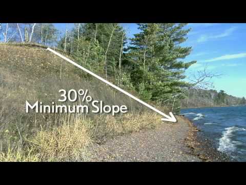

Impact
No impacts have been left for this site yet - be the first!


