3rd & Mission Streets
San Francisco
CA
Yerba Buena Gardens
Rezumat


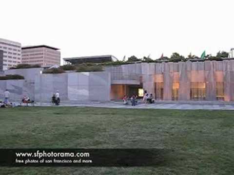
Owned by the San Francisco Redevelopment Agency, the Yerba Buena Gardens consist of two public parks connected by a pedestrian bridge. This site harbors public art exhibit block, a Martin Luther King Memorial, and the largest waterfall in the West Coast. Located on the North block of the garden is the Yerba Buena Center for the Arts, while the South block contains an ice skating rink, bowling alley, carousel, and a children’s musem called Zeum. (Restaurants are located throughout the two blocks.)

Location:
Javascript este necesar pentru a vizualiza harta.
Comentarii
Conexiuni
Compare related sites, explore the related maps, find out about volunteering, how to get here and more. Soon, you will find ways to share this map here, too.
Every site using the same primary Icon on Open Green Map is automatically linked here. You can compare different approaches and solutions on this map and others around the world.
Choose a connections category from the list on the left.
Other Sites on Map
-
- San Francisco
- San Francisco
- San Francisco
- San Francisco
- San Francisco
- San Francisco
- San Francisco
- San Francisco
- San Francisco
Related Sites Worldwide
- RichmondUnited States
- Staten IslandUnited States
- Ronneby
- North PortUnited States
- New YorkUnited States
- CardiffUnited Kingdom
- Cluj NapocaRomania
-
- Indianapolis
-
- United States
- United States
- Lebanon
- CardiffUnited Kingdom
- BerlinGermany
- RichmondUnited States
- BaltimoreUnited States
- New Orleans
- SarasotaUnited States
- Indonesia
- CardiffUnited Kingdom
- South Africa
- CardiffUnited Kingdom
- HancockUnited States
- SarasotaUnited States
Multimedia
 adăugat de


Impact
Anna Sep 2008 "I enjoy fresh air daily now, the walk is good through the park"
Newton Sep 2008 "I am rethinking all our purchasing at our company"
6 people discovered this site because of this map. Did you?


