Dwarsberg Point
概览
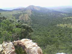

Located on the northern hiking route between Deelfontein and Thwane Camps in the Vredefort Dome area, Dwarsberg is the highest point in the Free State Dome. It also boasts the largest stand of Protea Caffra (sugarbush) in the Free State Province. This route and the Dwarsberg point offer the best views of the impact structure in the Dome.

Location:
Javascript is required to view this map.
评论
Connections
Compare related sites, explore the related maps, find out about volunteering, how to get here and more. Soon, you will find ways to share this map here, too.
Every site using the same primary Icon on Open Green Map is automatically linked here. You can compare different approaches and solutions on this map and others around the world.
Choose a connections category from the list on the left.
Other Sites on Map
Related Sites Worldwide
-
- University Heights美国
- 南非
- Ithaca美国
-
-
-
-
- Gainesville美国
-
-
- 意大利
-
- 新加坡
-
-
- North Port美国
- 黎巴嫩
- Gainesville美国
-
-
-
-
- Rio de Janeiro巴西
- Santana de Parnaíba巴西
Multimedia

Dwarsberg Point


Impacts
No impacts have been left for this site yet - be the first!


