Ferry Dock Road
Gloucester
NC 28528
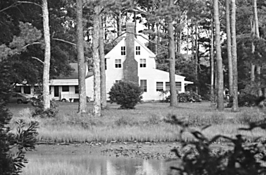
Thomas Bell House (Betsy Williams)
Overview


Built approximately 1760's by Thomas Bell. Main part of the house was built on ballist stones. Ballist stones were used prior to 1800's and was typical of foundations of houses built during that time.

Location:
Javascript is required to view this map.
Comments
Connections
Compare related sites, explore the related maps, find out about volunteering, how to get here and more. Soon, you will find ways to share this map here, too.
Every site using the same primary Icon on Open Green Map is automatically linked here. You can compare different approaches and solutions on this map and others around the world.
Choose a connections category from the list on the left.
Other Sites on Map
- Harkers Island
-
- Atlantic
- Atlantic
- sea level
- Atlantic
-
-
-
- Sealevel
Related Sites Worldwide
- Schooley's MountainUnited States
- United Kingdom
- BrooklynUnited States
- Young's PointCanada
- CFB BordenCanada
- GravenhurstCanada
- United Kingdom
- Taiwan
- New YorkUnited States
- United Kingdom
- Cape TownSouth Africa
- RichmondUnited States
- Romania
- United States
- New YorkUnited States
- PeterboroughCanada
- SwanseaUnited Kingdom
-
- Staten IslandUnited States
- HillsboroughUnited States
- QuincyUnited States
-
-
- WheelingUnited States
- MontclairUnited States
Multimedia

Thomas Bell House (Betsy Williams)

Impacts
No impacts have been left for this site yet - be the first!


