Cleveland
OH
Dike 14 Nature Preserve
Descripción

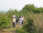
Since dredge deposits ceased in 1977, Dike 14’s 88 acres began its own self-regeneration and has been evolving with little human intervention.
The plan includes preserving and adding wildflower meadows, lowland woodlands, upland woodlands, a group of conifer trees, and a wetland. And new features include a multi-purpose trail, 20-foot high raptor viewing ramp connected to a 30-foot high raptor tower and a grove encircled with an earthen observation mound at the tip of the dike.

Location:
Javascript is required to view this map.
Comentarios
Conexiones
Compare related sites, explore the related maps, find out about volunteering, how to get here and more. Soon, you will find ways to share this map here, too.
Every site using the same primary Icon on Open Green Map is automatically linked here. You can compare different approaches and solutions on this map and others around the world.
Choose a connections category from the list on the left.
Other Sites on Map
- Cleveland
- Akron
- Brecksville
-
- Cleveland
Related Sites Worldwide
- SarasotaEstados Unidos
- DurhamEstados Unidos
- New YorkEstados Unidos
- Estados Unidos
- SecaucusEstados Unidos
- Estados Unidos
- North CharlestonEstados Unidos
- Cluj-NapocaRomania
- Baltimore, MDEstados Unidos
- Estados Unidos
- Port ElginCanadá
- Baltimore, MDEstados Unidos
- NewarkEstados Unidos
- RochesterEstados Unidos
- Staten IslandEstados Unidos
- LanseriaSur Africa
- BronxEstados Unidos
- Jersey CityEstados Unidos
- Estados Unidos
- Cesky KrumlovCzech Republic
- Brooklyn
- CharlestonEstados Unidos
- EnglewoodEstados Unidos
- Baltimore, MDEstados Unidos
- CaliColombia
Multimedia

 added by
Impactos
No impacts have been left for this site yet - be the first!


