Doyers Street
New York
10013
Doyers Street
Overview


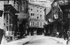
Doyers Street was originally a dead-end alley known as Dead Men's or Bloody Alley. During the tong war of 1920s, those who were chased into Doyers Street by rival tong members had no escape. The tong wars were the consequence of an increase in population as a result of migration from the West Coast, lack of resources, impermiable immigrant groups surrounding them, and prejudices held by outside communities that led to tongs vying over small areas of land to establish businesses and live their lives. Tensions were permanent throughout the history of Old Chinatown and even up to the 1930s.

Location:
Javascript is required to view this map.
Comments
Connections
Compare related sites, explore the related maps, find out about volunteering, how to get here and more. Soon, you will find ways to share this map here, too.
Every site using the same primary Icon on Open Green Map is automatically linked here. You can compare different approaches and solutions on this map and others around the world.
Choose a connections category from the list on the left.
Other Sites on Map
-
- New York City
- New York
- New York
- New York
- New York
- New York
Related Sites Worldwide
- Cesky KrumlovCzech Republic
- Brazil
-
- FlorianópolisBrazil
- South Korea
- BrooklynUnited States
- ConakryGuinea
- New YorkUnited States
- Las VegasUnited States
- OspreyUnited States
- DaliChina
- BrooklynUnited States
- Harkers IslandUnited States Minor Outlying Islands
- Hong Kong S.A.R., China
- BrooklynUnited States
- Jersey CityUnited States
- GlasgowUnited Kingdom
- YumboColombia
-
- HudsonUnited States
- New YorkUnited States
- Australia
- OcracokeUnited States
- OcracokeUnited States
- United States
Multimedia
 added by


Impacts
No impacts have been left for this site yet - be the first!


