Greater Mountain Lakes Open Space Area
![Public Forest/Natural Area: Natural Reserve, National Parks, Regional Parks, other parks and public forests, even private land that has been set aside for conservation. Balance your emphasis of forests with parklands to discourage the over-use of natural areas. Public Forest/Natural Area](https://www.opengreenmap.org/sites/default/files/taxonomy_image/category_pictures_73.gif)
![Wildlife Habitat: Native environment for animals and the plants that sustain them. Can represent native natural environments, or protected areas such as park reserves where larger animals and other wildlife can be found. Wildlife Habitat](https://www.opengreenmap.org/sites/default/files/taxonomy_image/category_pictures_83.gif)
![Native Forests/Plants: Flora that is indigenous in the region, sometimes called old growth, heirloom or indigenous species. Native species requires less water and care than exotic imports, and usually attract more birds, bees and butterflies, and help the cycle of life stay in balance. May include a master gardener, permaculturalist or horticulturalist or information center. Native Forests/Plants](https://www.opengreenmap.org/sites/default/files/taxonomy_image/category_pictures_75.gif)
![Wetlands: May be on an official protection list, as wetlands are important habitats and useful for water cleaning and protection from storm surges. May be natural, reconstructed or artificial. Wetlands](https://www.opengreenmap.org/sites/default/files/taxonomy_image/category_pictures_64.gif)
![Geological Feature: Where unusual or typical forms are apparent in the landscape. May be exposed rock layers, glacial till or a chasm view. Includes significant open space, prairie, desert, etc. May include an important mountain or other significant natural landmark. Geological Feature](https://www.opengreenmap.org/sites/default/files/taxonomy_image/category_pictures_67.gif)
![Bird and Wildlife Watching: Place to view animals in the wild. Officially recognized or locally-known sites could be accompanied by guidelines for viewing without harm, and details on the species you might see. May include organizations or wildlife centers that help protect animals. Bird and Wildlife Watching](https://www.opengreenmap.org/sites/default/files/taxonomy_image/category_pictures_90.gif)
Overview
Greater Mountain Lakes Open Space Area
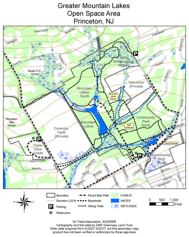
Often called Princeton’s “Central Park,” the Greater Mountain Lakes Open Space Area includes almost 300 acres of preserved, public open space and over 8 miles of walking trails. This network of trails connects the Mountain Lakes Preserve to Mountain Lakes North, John Witherspoon Woods, Community Park North, and the fields of Tusculum. The area features a series of lakes once used to harvest ice, a boulder field, a piney forest, and Devil’s Cave, as well as meadows and woods that once belonged to John Witherspoon.
Location: Parking is available off Mountain Avenue or Cherry Hill Road; both lots are marked by signs. Restrooms are available at the Mountain Avenue parking area.
For trail maps, and other information, please visit NJ Trails.
Location:
Comments
Connections
- Saint CharlesUnited States
-
- CardiffUnited Kingdom
- São JoséBrazil
- Gates MillsUnited States
- shanghaiChina
- SarasotaUnited States
- FifeUnited Kingdom
-
- Utica
- PereiraColombia
- shanghaiChina
- South Africa
- SwanseaUnited Kingdom
- JacksonvilleUnited States
- Saint LouisUnited States
- New YorkUnited States
- West SlatervilleUnited States
-
- SarasotaUnited States
- Brazil
- Hong Kong S.A.R., China
- United Kingdom
- Canada
- EnglewoodUnited States
Multimedia
![](https://www.opengreenmap.org/sites/default/files/imagecache/320max/user_upload/mlga_trail_map.jpg)
Greater Mountain Lakes Open Space Area
Impacts
No impacts have been left for this site yet - be the first!