Cali
VDC
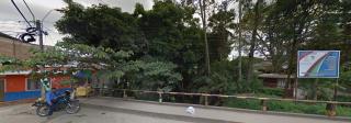
TRAMO 4 Norte
Descripción


Tramo entre la Calle 6 Oeste y la Calle 2 Oeste. Todavía se conserva en este sector el ambiente natural de las riberas del Río Cañaveralejo.Sin embargo, esta invadida la franja de protección por viviendas.

Location:
Javascript is required to view this map.
Comentarios
Conexiones
Compare related sites, explore the related maps, find out about volunteering, how to get here and more. Soon, you will find ways to share this map here, too.
Every site using the same primary Icon on Open Green Map is automatically linked here. You can compare different approaches and solutions on this map and others around the world.
Choose a connections category from the list on the left.
Other Sites on Map
- Cali
- Cali
- Cali
- Cali
- Cali
- Cali
- Cali
- Cali
- Cali
- Cali
Related Sites Worldwide
- BronxUnited States
- Staten IslandUnited States
- India
- BrooklynUnited States
- SingaporeSingapore
- Lebanon
- United States
- Cottage LkaeUnited States
- ManhattanUnited States
- Sudbury
- EspooFinland
- KinnakeetUnited States
- Bedford StuyvesantUnited States
- Romania
- Longboat KeyUnited States
- BronxUnited States
- Cottage LkaeUnited States
- SarasotaUnited States
- Long ValleyUnited States
- New YorkUnited States
- Alloa
- United States
- United States
- CharlestonUnited States
- 독일
Multimedia

TRAMO 4 Norte

Impactos
No impacts have been left for this site yet - be the first!


