2300 Placida Road
Englewood
FL 34224
Cedar Point Environmental Park
Overview

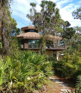
Cedar Point Environmental Park is across from Lemon Bay High School and borders Ainger Creek, Oyster Creek, and Lemon Bay. Cedar Point has three hiking trails, a butterfly garden, historical Cookie House, and an American Bald Eagle’s nest. The visitor’s center is open to the public and has free maps, literature, and a board of local environmental co-ops. Cedar Point makes a point to protect the wildlife and participates in the Great American Cleanup.
-Bryan Knight, student at SCF sustainability class.
Sustainability Englewood and Venice FL -Bryan Knight, student at SCF sustainability class
updated 03/2018 by SCF-BK
updated 03/2018 by SCF-BK

Location:
Javascript is required to view this map.
Comments
Connections
Compare related sites, explore the related maps, find out about volunteering, how to get here and more. Soon, you will find ways to share this map here, too.
Every site using the same primary Icon on Open Green Map is automatically linked here. You can compare different approaches and solutions on this map and others around the world.
Choose a connections category from the list on the left.
Other Sites on Map
- Englewood
- Englewood
Related Sites Worldwide
- MalmöSweden
- BrooklynUnited States
- BaltimoreUnited States
- VeniceUnited States
- Colombia
- OaklandUnited States
- BrooklynUnited States
- Kenya
- San FranciscoUnited States
- Brooklyn, NYUnited States
- OaklandUnited States
- San FranciscoUnited States
-
- VeniceUnited States
- OaklandUnited States
- BarcelonaSpain
- Taiwan
- AustinUnited States
- United States
- NewarkUnited States
- OaklandUnited States
- ClevelandUnited States
- OaklandUnited States
- AvonUnited States
- San FranciscoUnited States
Multimedia

Cedar Point Environmental Park

Impacts
No impacts have been left for this site yet - be the first!


