Oxbow Lake
このサイトについて


OXBOW LAKE
This type of lake can be described as "the bends of [where] two meanders meet" (2019). The two meanders bypass the curve of the river which creates an oxbow, or u-shape, which may then be infilled with overwash sediment. This is part of a meandering stream. A meandering stream has one channel that runs in a snake-like motion through a valley. Since the water flows around each curve, the outer edge of the water tends to move faster than the inner workings of it. As a result, an erosion is created on the outer edge which is also known as a "cut bank" and a deposition is created on the inner edge known as a "point bar" (2019). Meanders tend to change positions by "eroding sideways and slightly downstream" (2019). This happens because "the maximum velocity of the stream shifts toward the outside of the bend, causing erosion of the outer bank" (2019). Meanders can become more narrow in order to form an oxbow lake. At some point, oxbow lakes can even dry up due to the meander becoming so narrow that it cuts off that portion of the river, which ultimately leaves it dried up in a "U" shape. Some examples of oxbow lakes are Flag Pond, Horseshoe Lake, and Cottonwood Cutoff.
Sources:
Fluvial Features-Meandering Stream (U.S. National Park Service). (2019, February 27). Retrieved July 07, 2019, from https://www.nps.gov/articles/meandering-stream.html
Rtaylorsmith. (2012, March 04). Meanders and Oxbow Lakes. Retrieved July 07, 2019, from https://www.youtube.com/watch?edufilter=NULL&v=4qKS_Nk7UmY

Location:
コメント
コネクション
- ConakryGuinea
- BrooklynUnited States
- CranfordUnited States
- University HeightsUnited States
- RingoesUnited States
- OcracokeUnited States
- HaddonfieldUnited States
-
- NewarkUnited States
- スイス
- PalmyraUnited States
- CarlisleUnited States
- Brazil
- 宇治市Japan
- FanwoodUnited States
- MountainsideUnited States
- United States
- United States
- VeniceUnited States
- United States
- United States
- United States
- Greece
- RochesterUnited States
- SummitUnited States
マルチメディア
 added by
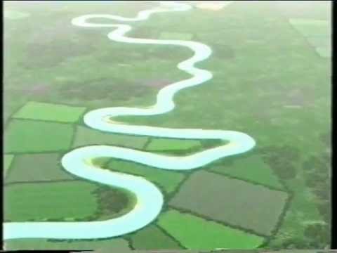

インパクト
まだ誰からもインパクトは報告されていません!一番目になりませんか?


