Northwest 7th & Northwest "A" Street
Richmond
IN 47374
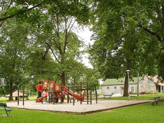
Mary Scott Park
このサイトについて


The Mary Scott Park features:
An open air-shelter
Picnic Area
Playground
Originally known as North West Seventh Street Park, Mary Scott Park became the first park located on the west side of Richmond. The history of the park started with the land being originally owned by the Peacock Family. The Peacock Farm extended from North west Fifth Street west to approximately North West Thirteenth Street on the north side of Main Street. The Farm was later broken up as Richmond began to expand west. The area was being developed as the Beeson & Sedgwick Addition. Within the area was a beautiful forest known by the citizens of the area as Middleton’s Woods. (Credit Waynet.org).

Location:
Javascript is required to view this map.
コメント
コネクション
ここでは、関連したサイトと比較、地図の探索、ボランティアについてやこのサイトへの行きかたなどがわかります。
このグリーンサイトと同じ第一アイコンを指定しているサイトは自動的にここに表示されます。ここに表示されているほかのサイトを見て比較してみよう。
Choose a connections category from the list on the left.
この地図にある関連サイト
- Richmond
- Richmond
- Richmond
- Richmond
- Richmond
- Richmond
- Richmond
世界中の関連サイト
- United States
- BallwinUnited States
- North PortUnited States
- SeattleUnited States
-
- New YorkUnited States
- Brazil
- Hong Kong S.A.R., China
- OaklandUnited States
- BaltimoreUnited States
- WheelingUnited States
- SarasotaUnited States
- SwanseaUnited Kingdom
-
- United States
- Japan
-
-
- BaltimoreUnited States
- OaklandUnited States
- DecaturUnited States
- OaklandUnited States
- Canada
- North PortUnited States
- Upper MarlboroUnited States
マルチメディア
Mary Scott Park


インパクト
まだ誰からもインパクトは報告されていません!一番目になりませんか?


